Fourth county added to orange rain warnings as flooding expected
Ellen O'Donoghue, Sarah Slater and Vivienne Clarke
Louth has been added to the list of counties under orange rainfall warnings, with other advisories expanded elsewhere in the country.
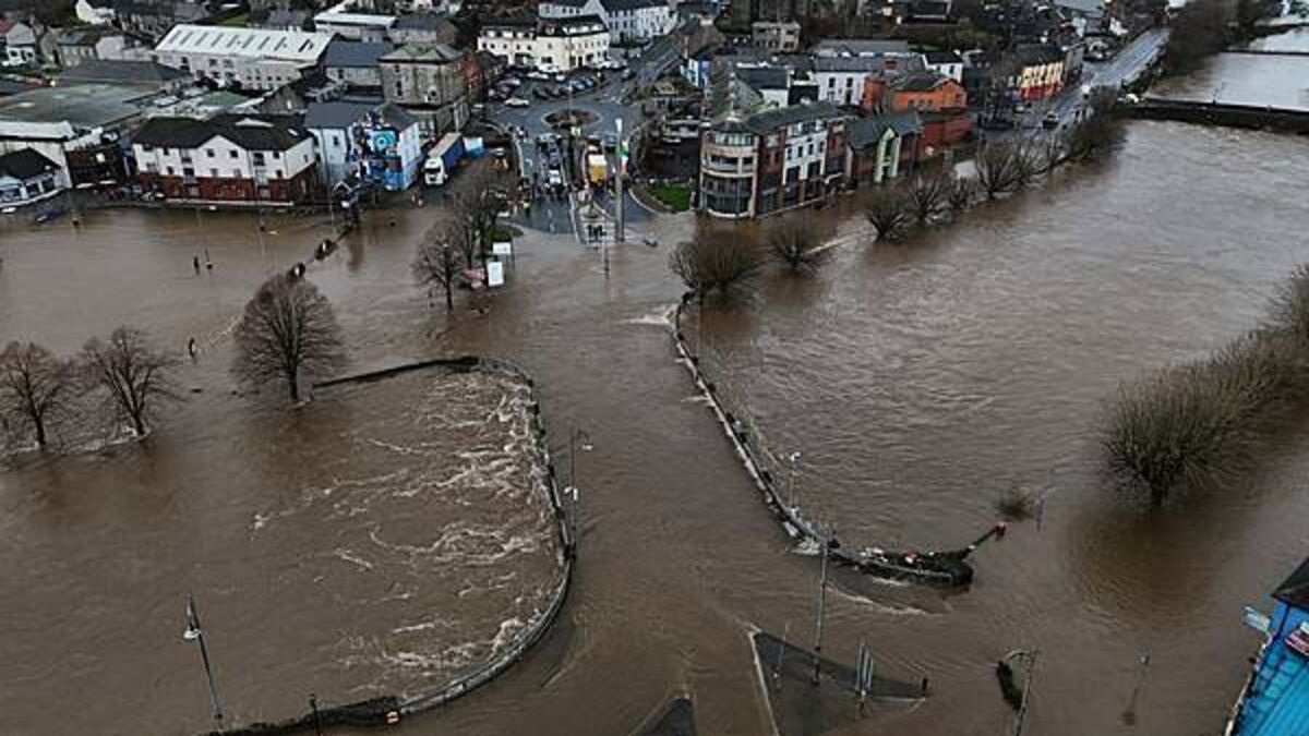
Weather warnings have been issued for 13 counties, with the worst impacts projected for areas that were already severely affected by flooding in recent days.
Affected counties are likely to experience more flooding during spells of further heavy rain on Thursday and Friday.
Met Eireann said spells of “very heavy rain” will be falling on “already saturated ground”.
â¼ï¸Updates:
ð Status Orange Rainfall warning issued for Dublin, Valid 12:00 today until 12:00 06/02
â¡ï¸A Status Yellow Rainfall warning issued prior to Orange for Wicklow & Dublin, 09:00-12:00 today
â¡ï¸Timing updates issued to other warnings.
Visit: https://t.co/w5QtJ1V6un pic.twitter.com/QZAzzLsw87— Met Éireann (@MetEireann) February 5, 2026
This, combined with high river levels and high tides, is likely to lead to localised flooding and river flooding as well as difficult travel conditions.
Weather warnings:
- Status Orange - Rain warning for Dublin, Wicklow from 12pm Thursday to 3pm Friday.
- Status Orange - Rain warning for Waterford from 9am Thursday to 9am Friday
- Status Orange - Rain warning for Louth from 12pm Thursday to 6pm Friday
- Status Yellow - Rain warning for Carlow, Kildare, Kilkenny, Laois, Wexford, Tipperary from 9am Thursday to 9am Friday
- Status Yellow - Rain warning for Cavan, Monaghan, Meath from 12am Thursday to 6pm Friday
- Yellow - Rain Warning for Antrim, Armagh, Down, Tyrone, Derry from 12pm Thursday to midnight on Friday
The National Emergency Co-ordination Group has warned of “another challenging phase”.
In advance of the latest spell of heavy rain, local authority teams have been deploying sandbags, clearing drains and carrying out other flood prevention works.
In Enniscorthy Fianna Fáil councillor Aidan Browne said: “One of the interim measures for flood relief is currently being installed at the Island Road.
“This is a wall of one tonne of sand bags which is placed at back of the vulnerable houses to create a line of defence against flood waters (from the river Slaney)”.
Wicklow County Council are highlighting that sandbags are available for collection across all Municipal Districts. Stocks will be replenished throughout the day.
Collection Points are Arklow Depot, Aughrim Depot, Avoca Depot, Blessington Council Depot, Chapel Lane Baltinglass, Donard Council Depot, Dunlavin Council Depot, Tinahely Council Depot, Kilmacanagoue Carpark, Bray MD Depot and Bog Meadow, Enniskerry.
Due to high tides and high easterly winds, the public is being advised by Wicklow County Council to stay away from the following areas
- Bray promenade which is flooded,
- Bray harbour, Martello car park and
- Bray south Promenade car park
The Government has offered financial support for homes and businesses affected by recent flooding.
Following recent rainfall, many rivers are at or above bank-full levels.
Meanwhile, strong onshore winds and storm surge will increase the risk of wave overtopping and coastal flooding.
Dublin City Council has said it is monitoring river levels and coastal conditions closely, to ensure appropriate responses as required.
Carparks along Sandymount and Clontarf coast have been closed to protect against possible wave overtopping, while the Council has also closed the Clontarf cycle lane as a precautionary measure.
Eden Quay Boardwalk (floodgates) also remains closed, as do the floodgates along the River Dodder.
In Co Wexford, burst water mains in Kilmore are affecting the village, nearby Bridgetown, Tomhaggart and surrounding areas. “Works are (expected) to be completed this evening. Pressure should return soon after,” said local Aontú councillor Jim Codd.
Waterford Sinn Féin TD David Cullinane said that financial resources made available for Waterford shows the town and county lags way behind Cork, Limerick, Galway, Kilkenny and many more counties over the last five years.
“Likewise in funding for harbours and piers, where Waterford received the lowest allocation,” added Cullinane.
He highlighted that Waterford ranks 22nd out of 24 counties for Office of Public Works (OPW) major flood relief funding.
Over six years, Waterford received just €240,000, the Sinn Féin TD claims.
Cork received €115 million. Limerick €37 million, Galway €13 million, Kilkenny €4 million, 17 times more than Waterford.
“This neglect is unacceptable. Waterford deserves fair funding and real flood protection.”
A very, very wet day
Met Éireann has warned that very heavy rain falling on already saturated ground, combined with high river levels and high tides will lead to localised flooding, river flooding, and difficult travel conditions.
The National Emergency Co-ordination Group met on Wednesday and warned of “another challenging phase”.
Local authority teams have been deploying sandbags, clearing drains and carrying out other flood prevention works.
The Government has offered financial support for homes and businesses affected by recent flooding.
Following recent rainfall, many rivers are at or above bank-full levels.
Meanwhile, strong onshore winds and storm surge will increase the risk of wave overtopping and coastal flooding.
Senior forecaster with Met Éireann, Gerry Murphy, has warned “it is going to be a very, very wet day” with rain continuing to fall until mid-afternoon on Friday.
“This is going to be a lot of consistent, persistent rain," he added, but the rain will arrive more slowly than anticipated.
Speaking on both Newstalk Breakfast and RTÉ radio’s Morning Ireland, Murphy also cautioned that the rain, particularly in the Dublin mountains, is going to have a “knock-on” effect at lower levels in areas such as Shankill and Rathfarnham and other parts of South County Dublin.
This weather regime is going to continue, today, tomorrow, over the weekend, with a further band next week, he added.
"Once this rain does get started this morning, it's actually going to continue right the way through the rest of the day, overnight and through tomorrow morning as well. So there's going to be rain where basically it's just going to continue raining from once it starts mid-morning and then basically it's just rain, rain until maybe mid-afternoon tomorrow," Murphy said.
“As has been well documented at this stage, the river levels are very high, the tides are high, the ground is saturated, so moderate amounts of rainfall can and probably will cause flooding in some places, but this is actually going to be a very wet day."
Rainfall in the Wicklow Mountains will have the effect of “activating some very responsive rivers and streams in the mountains, which then will have a knock-on effect as it flows down to lower levels," according to Murphy.
"But it does look like those heavier, those more significant high rainfall totals will also encroach into the Dublin mountains and parts of South Dublin.
Rainfall for January and the start of February has been well above average for the south and east of the country, "so it doesn't take much to tip into a flooding scenario".
Additional reporting: PA


